Hackathon Projects
Test Link Test Tweet – Text ANCHEALTH to 888-777 – URL: Send a Text
This Hackathon is the first event of Code for America‘s National Day of Civic Hacking (Fun fact: I can be seen in some of the banner photos trying to figure out the best empanada to eat) taking place all over the United States June 6th and earlier.
0.) National Challenges from the US government departments and other groups.
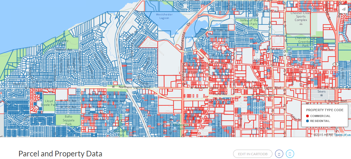
1.) Work with Muni Property Tax and Parcel data. Check the version of the geojson in Github. https://github.com/codeforanchorage/moa_property_tax_geojson
Rough example with Residential in red and Commercial in blue. Click on a border to see more info about a property. http://cdb.io/1EDyHgE
Create a Anchorage Centennial animation of buildings built in the last 100 years. Can we do this for parks and trails as well?
Example uses with the NYC data Parser is written in Python.
Enter height data into Open Street Maps to show the shadows during anytime and day of the year. http://osmbuildings.org/examples/Shadows.php?lat=61.21842&lon=-149.89818&zoom=16
2.) United Way has a People Mover bus wrapped. They want a contest where people drop a pin on a map where they have seen the bus (and possibly upload a picture) The person would also enter a name and email that can be contacted from a contest drawing. The bus will be running until March 2016. They are looking for a possible WordPress solution. Here is a possible starting point. (CartoDB and Javascript) http://cartocrowd.herokuapp.com/
3.) Realtime Bus SMS project – Node.js https://github.com/codeforanchorage/realtime-bus-sms A few more enhancements like showing 2 or 3 closest stops. Maybe allowing people to respond with a keyword to get the most recent update. Design clean up.
4.) Accessibility map for Anchorage. http://www.accessmapseattle.com/ and http://www.geekwire.com/2015/app-that-helps-people-in-wheelchairs-plan-travel-routes-wins-first-place-at-civic-hackathon/ Data needed Elevation data from Google API, Bus stop data, construction data. (python) https://github.com/Hackcessible/hackcessible-webapp
I have some rough data for construction and sidewalk shape files.
5.) Find the shortest route to hit all 25 bike to work stations in Python. http://www.randalolson.com/2015/03/08/computing-the-optimal-road-trip-across-the-u-s/ and using the data from here: https://www.google.com/maps/d/u/0/viewer?mid=z2LjXzGeqziw.kvF7uZpQl1nI
Could also be done for parks, breweries, etc.
6.) Help match restaurants and people with extra waste food with farmers and composters who could use the food waste.
7.) SNAP Pre-Screener – Ruby on Rails https://github.com/mRelief/mrelief_snap_screener_example Example app: https://cloud.githubusercontent.com/assets/451510/7357999/7699a4a4-ece7-11e4-9da6-751a0336075b.gif
Data: http://dhss.alaska.gov/dpa/Pages/fstamps/default.aspx#income
8.) Recreational API, can we see what cabins and campgrounds are available. Was thinking of Denali lottery but it involves paying by credit card. http://openglobe.github.io/myamerica-devsummit/ https://github.com/OpenGlobe/myamerica-devsummit/blob/gh-pages/README.md
We also have data for Oct-Dec 2014 of reservations made at National Parks. Are there interesting visualizations that can be made.
9.) GIS edit Muni park data for use in a heat map showing how close people are to parks. Can also be used for an app that culls instagram and flickr to show people having fun in park boundaries. http://www.caliparks.org/ Could also be used for click-that-hood to learn where parks are. http://cdb.io/1e7rtez Data from this page: http://munimaps.muni.org/moagis/download.htm
10.) Help update and revise a map of where you can get local food. Showing where farms, farmer’s markets, breweries, restaurants that serve local food, etc. http://cdb.io/1JnVzGH
11.) We have lots of great trail data that could be hacked on https://github.com/codeforanchorage/trailstranscoder. See what the data looks like on a map: http://codeforanchorage.org/trailstranscoder-mobilebrowser (takes a while to load in certain regions) And check out how Mike Brook,who along with Matthew Dillon worked on organizing the data, uses it in the Find Yourself in Kincaid app. https://itunes.apple.com/us/app/find-yourself-in-kincaid-park/id944507071?mt=8
No commentsNo comments yet. Be the first.
Leave a reply